Last Mile Connectivity: Understanding the Accuracy of Point-to-Point Navigation
"A step toward seamless and precise navigation all the way to the front door"
What it is about
Have you ever been hungry and ordered food just to end up wondering where the delivery person got lost? Ever been dropped off at a wrong location, having to walk down all the way to the actual location? Ever had to find an alternative route because the one suggested was not accessible?
Then you understand the importance of last mile connectivity – seamless and precise navigation until the doorstep.
Our web map shines a light onto the last mile problem by allowing users to interactively explore the limits of two different navigational services.
How we built it
From OpenStreetMap we acquired spatial data relevant for navigation such as wheelchair accessible facilities, stairs, and lit streets during the night, using the query tool Overpass Turbo. Mapbox’s GL JS library was a key tool to setting up our web map. It further allowed us to style our base map and to store and display the data we picked as tilesets sensitive to different zoom levels.
To get two different sets of directions onto our map - its centerpiece - we drew on Mapbox’s Direction API and OpenStreetMap API.
Finally, among other features we added a night mode because why not!
Challenges we ran into
Initially, we had doubts if we could achieve everything we set out to do with the code. We wanted to avoid having to manually design what we wouldn’t be able to code. Similar story for the night mode. It took a lot of research and time until we could implement it in a reasonably satisfactory way.
What we're proud of
Our web map is simple and intuitive to use. It’s look stands out without distracting from its purpose. We are proud that users can get information about any starting point and destination they desire.
What we learned
We are amazed by the sheer volume of high-quality services and web tools available and the magic of learning how to use and combine a variety of them. Our understanding of the value of not only having tidy code, but also spatial visualization of last mile connectivity information has improved.
What's next
We would like to improve the experience of navigating the first/last mile even more by closing the remaining gaps in directions at origin or destination. We envision something like it’s demonstrated in the following video for any route.

Complete user interface of the web map, with legend added.
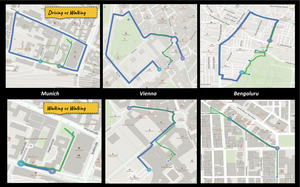
Comparative routes between OpenStreetMap API (green) and Mapbox Navigation API (blue).
Night map with all the lit vs non-lit streets and walkways.
Students
Poornima Badrinath
Oskar Baumann
Oskar Baumann
11th intake
Supervisors
Juliane Cron, M.Sc.
Dr.-Ing. Mathias Jahnke
Dr.-Ing. Mathias Jahnke
Keywords
interactive, web map, first/last mile, navigation, directions, transportation, modes, connectivity, accessibility
Try it