Beers are one of the main attractions of Munich, which captivates people from all over the world. Behind this iconic beverage lies years of history, ownership transfers, market strategies and scientific developments in the beer industry that has shaped this city. This project attempts to map key aspects of the Bavarian Beer culture and tries to read Munich as a Beer City. It becomes necessary to ask the question, “How do we represent the city through its Beer Infrastructure?”. For this purpose, the study is framed into the following three-part structure: Where is the beer produced? Where is the beer distributed? Where is the beer consumed? This shall help us to understand how Beer flows in the city of Munich. Apart from understanding the structure of Beer in the city, we can also use the maps to plan beer tours in Munich based upon various interesting parameters such as the type of restaurant, urban attractions like museums or historic places and open space proximity to the point of sale. The maps can open up infinite possibilities for us to the experience of the city through its trademark beers. We hope you enjoy this story map with your favourite Munich Beer!
Fantastic Beers and Where to Find Them
“Mapping the Production, Distribution and Consumption of Munich Beers”

The Beer Map
What it is about
How we built it
To represent Munich as a Beer City, it was necessary to collect all the spatial information related to the six Munich Breweries. The locations of the breweries and its consumption points were extracted directly from their websites and integrated under the same data format to be mapped together. Once all the geographic information was placed, various geoprocessing methods such as Kernel Density Estimation (KDE), Point Clustering, Thiessen Polygons and Routing Algorithms were used to analyze the spatial distribution. The results were studied in relation to the existing urban transit infrastructures like U-Bahn networks, Road Networks and existing points of interest to start drawing new districts and neighborhoods that contain a high-density of beer consumption points.
Challenges we ran into
The main challenge was data acquisition and filtering. As a first step of entire visualization pipeline, it was necessary to invest a great amount of time to collect and pre-process the data of six different brands and filter the most valuable information to make it a part of comparable spatial styles.
What we're proud of
We were able to accomplish the goals we set out in the beginning while working remotely in Indian and Venezuela before arriving in Germany. For us as international students, this project was a valuable way to get to know the city and its culture though mapping its historical beers. We were able to integrate our backgrounds in geography, architecture, urban studies and spatial analysis in a project that was challenging and playful to execute. Furthermore, integrating the spatial information of the six breweries of Munich into a set of maps was a milestone in itself. The results can be used to show another perspective of a city famous for its mugs overflowing with the finest beers in the world.
What we learned
We learned to manage heterogenous spatial information and successfully make it part of interactive maps. We redefined our data collection workflows, learnt how to apply knowledge acquired from the Geomarketing, Geovisualization and Geoinformation lessons. It was also an interesting to work as a team coming from different professional backgrounds and countries.
What's next
We plan to take this project ahead by trying to collect more spatial datasets about the Munich Beers and exploring other kinds of geo-spatial analysis. Another possibility is to look for more study area frameworks which are based on various other urban phenomenon. Another step forward would be to see the historic evolution of the six Munich Breweries within the urban fabric of the city. During our study we also came across a variety of non-spatial data about the Munich beers such as types of flavors, recipes, important events, key figures, logo and bottle designs which could be visualized and intersected with the maps.
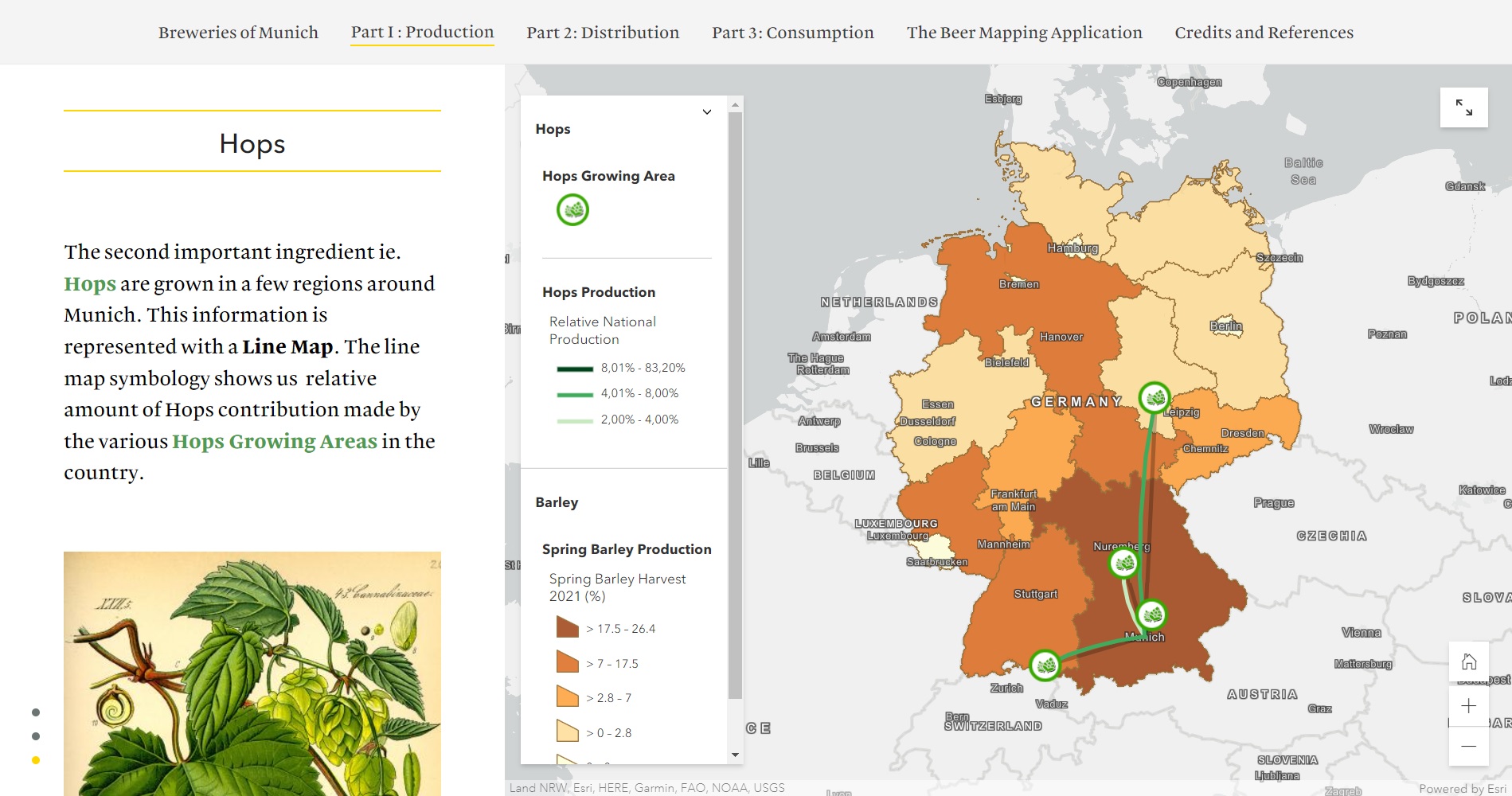
Production of the main ingredients to make Munich Beers.
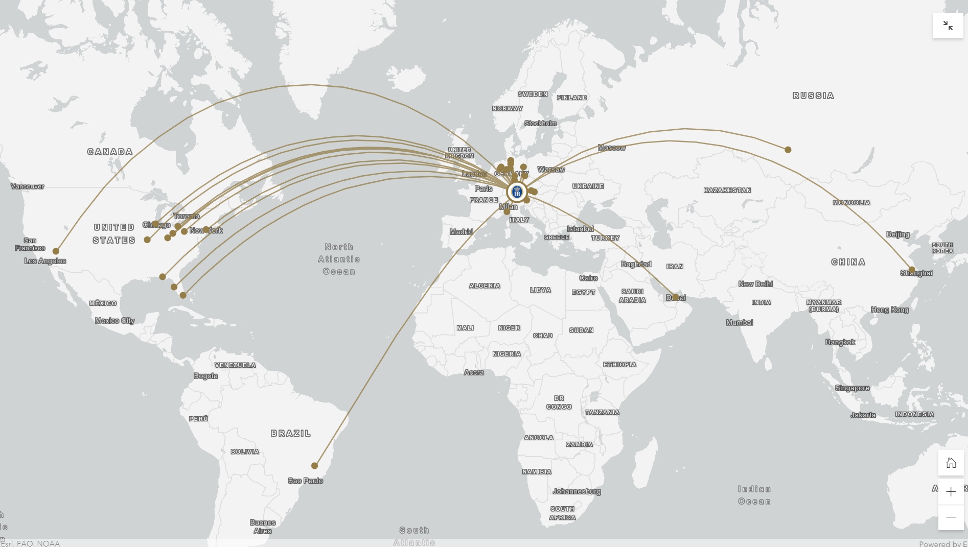
Distribution of Hofbräu Bar / Restaurants around the world.
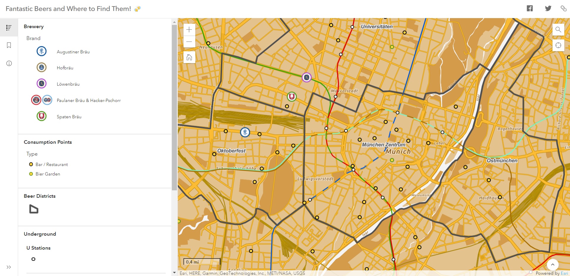
The Beer Mapping Application! Navigate the map and find the best places to drink beers in Munich.
Sources
The Six Breweries and the Oktoberfest
Trademarks and Munich beer
The German Purity Law (Das Reinheitsgebot)
Barley Production Information
Hops Production Information
Augustiner Bräu - Information and Locations
Hofbräu - Information and Locations
Paulaner Bräu - Information and Locations
Hacker-Pschorr - Information and Locations
Löwenbräu - Information
Spaten Bräu - Information
Beer Gardens - Information and Locations
Munich Points of Interest and Touristic Routes Zu Füß durch München (On foot through Munich) by Marko Roeske (Book)
Open Street Maps - Complimentary cartographic information
Esri - Basemaps, GIS spatial analysis and visualization tools
Students
Mihir Desai
Eliezer Fajardo
Eliezer Fajardo
11th intake
Supervisors
Juliane Cron, M.Sc.
Dr.-Ing. Mathias Jahnke
Dr.-Ing. Mathias Jahnke
Keywords
Munich, Beer, Brewery, Routes, Neighborhood, District, Geomarketing
Try it